Comfy Saturday temps; chance of scattered showers and storms
Hurricane Isaias moves closer to Florida
Last Saturday was steamy. This Saturday will feature comfortable temperatures and dew points. Saturday afternoon highs are expected to reach the 70s across much of Minnesota, with lower 80s in Twin Cities metro area, southeastern Minnesota and most of western Wisconsin.
Cool air spreads southward on Sunday
Sunday highs will be in the 70s across most of Minnesota, with 60s in northeastern Minnesota and parts of western Wisconsin:

Sunday dew points will be in the comfortable 50s in most spots:
Create a More Connected Minnesota
MPR News is your trusted resource for the news you need. With your support, MPR News brings accessible, courageous journalism and authentic conversation to everyone - free of paywalls and barriers. Your gift makes a difference.

Incredibly dry dew points in the 40s are expected in parts of far northern Minnesota.
The week ahead
Twin Cities metro area highs are projected to reach the mid 70s Monday and Tuesday, followed by upper 70s Wednesday, around 80 on Thursday and lower 80s on Friday.
Rain and thunder chances
Most of northwestern Minnesota will have a rain-free Saturday. The remainder of Minnesota plus western Wisconsin could see scattered showers and thunderstorms at times Saturday and Saturday night. A few spots could see a strong thunderstorm.
You can hear updated weather information on the MPR network, and you’ll see updated weather info on the MPR News live weather blog.
Forecast models show an isolated shower chance on Sunday in eastern Minnesota and western Wisconsin.
Hurricane Isaias is moving toward Florida
At 10 a.m. CDT Saturday, the center of Hurricane Isaias was 40 miles west-southwest of Nassau in the Bahamas. Max sustained winds were 80 mph and the center of Isaias was moving northwestward at 12 mph.
The NWS National Hurricane Center has this projected track for Isaias over the next few days, along with the cone of uncertainty for the track:
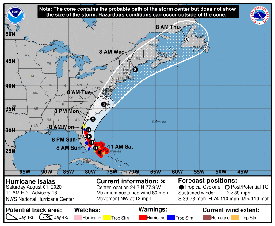
Hurricane warnings have been posted for much of the east coast of Florida. Here’s the NHC Saturday morning update on Hurricane Isaias:
BULLETIN Hurricane Isaias Advisory Number 18 NWS National Hurricane Center Miami FL AL092020 1100 AM EDT Sat Aug 01 2020 ...ISAIAS MAKING LANDFALL ON NORTHERN ANDROS ISLAND... ...EXPECTED TO APPROACH THE SOUTHEAST COAST OF FLORIDA LATER TODAY AND SUNDAY... SUMMARY OF 1100 AM EDT...1500 UTC...INFORMATION ----------------------------------------------- LOCATION...24.7N 77.9W ABOUT 40 MI...60 KM WSW OF NASSAU ABOUT 135 MI...220 KM SSE OF FREEPORT GRAND BAHAMA ISLAND MAXIMUM SUSTAINED WINDS...80 MPH...130 KM/H PRESENT MOVEMENT...NW OR 315 DEGREES AT 12 MPH...19 KM/H MINIMUM CENTRAL PRESSURE...987 MB...29.15 INCHES WATCHES AND WARNINGS -------------------- CHANGES WITH THIS ADVISORY: The Tropical Storm Watch from the Volusia/Flagler County Line to Ponte Vedra Beach Florida has been changed to a Tropical Storm Warning. A Tropical Storm Watch has been issued from north of Ponte Vedra Beach Florida to Altamaha Sound Georgia. SUMMARY OF WATCHES AND WARNINGS IN EFFECT: A Hurricane Warning is in effect for... * Boca Raton to the Volusia/Flagler County Line Florida * Northwestern Bahamas A Hurricane Watch is in effect for... * Hallandale Beach to south of Boca Raton Florida A Storm Surge Watch is in effect for... * Jupiter Inlet to Ponte Vedra Beach Florida A Tropical Storm Warning is in effect for... * North of Ocean Reef to south of Boca Raton Florida * Lake Okeechobee * Volusia/Flagler County Line to Ponte Vedra Beach Florida A Tropical Storm Watch is in effect for... * North of Ponte Vedra Beach Florida to Altamaha Sound Georgia Interests elsewhere along the southeast coast of the United States should monitor the progress of Isaias. Additional watches or warnings may be required later today. A Hurricane Warning means that hurricane conditions are expected somewhere within the warning area. A warning is typically issued 36 hours before the anticipated first occurrence of tropical-storm-force winds, conditions that make outside preparations difficult or dangerous. Preparations to protect life and property should be rushed to completion. A Hurricane Watch means that hurricane conditions are possible within the watch area. A watch is typically issued 48 hours before the anticipated first occurrence of tropical-storm-force winds, conditions that make outside preparations difficult or dangerous. A Storm Surge Watch means there is a possibility of life- threatening inundation, from rising water moving inland from the coastline, in the indicated locations during the next 48 hours. For a depiction of areas at risk, please see the National Weather Service Storm Surge Watch/Warning Graphic, available at hurricanes.gov. A Tropical Storm Warning means that tropical storm conditions are expected somewhere within the warning area within 36 hours. A Tropical Storm Watch means that tropical storm conditions are possible within the watch area, generally within 48 hours. For storm information specific to your area in the United States, including possible inland watches and warnings, please monitor products issued by your local National Weather Service forecast office. For storm information specific to your area outside of the United States, please monitor products issued by your national meteorological service. DISCUSSION AND OUTLOOK ---------------------- At 1100 AM EDT (1500 UTC), the center of Hurricane Isaias was located by an Air Force Reserve Hurricane Hunter aircraft and Bahamas radar near latitude 24.7 North, longitude 77.9 West. Isaias is moving toward the northwest near 12 mph (19 km/h). A general northwestward motion with some decrease in forward speed is expected for the next day or so, followed by a north-northwestward motion by late Sunday. On the forecast track, the center of Isaias will move over northern Andros Island during the next few hours and move near or over Grand Bahama Island in the Northwestern Bahamas later today. Isaias is forecast to move near the east coast of the Florida peninsula tonight through Sunday. Reports from the reconnaissance aircraft indicate that maximum sustained winds have decreased slightly to near 80 mph (130 km/h) with higher gusts. Little change in strength is expected through Sunday, and Isaias is forecast to remain a hurricane during this time. Slow weakening is expected to begin by late Monday. Hurricane-force winds extend outward up to 25 miles (35 km) from the center and tropical-storm-force winds extend outward up to 115 miles (185 km). Reports from a U.S. Navy site on Andros Island indicate that sustained winds of 45 mph (76 km/h) and a gust to 69 mph (111 km/h) occurred about 3 hours ago. More recently, a sustained wind of 35 mph (56 km/h) and a gust to 48 mph (77 km/h) were measured at Nassau, Bahamas. The estimated minimum central pressure is 987 mb (29.15 inches). HAZARDS AFFECTING LAND ---------------------- Key messages for Isaias can be found in the Tropical Cyclone Discussion under AWIPS header MIATCDAT4, WMO header WTNT44 KNHC, and on the web at www.hurricanes.gov/text/MIATCDAT4.shtml. STORM SURGE: The combination of a dangerous storm surge and the tide will cause normally dry areas near the coast to be flooded by rising waters moving inland from the shoreline. The water could reach the following heights above ground somewhere in the indicated areas if the peak surge occurs at the time of high tide... Jupiter Inlet to Ponte Vedra Beach FL...2-4 ft North Miami Beach to Jupiter Inlet FL...1-3 ft The deepest water will occur along the immediate coast near and to the right of the center, where the surge will be accompanied by large waves. Surge-related flooding depends on the relative timing of the surge and the tidal cycle, and can vary greatly over short distances. For information specific to your area, please see products issued by your local National Weather Service forecast office. A dangerous storm surge will raise water levels by as much as 3 to 5 feet above normal tide levels in areas of onshore winds in the Northwestern Bahamas. WIND: Hurricane conditions will continue to spread over the Northwestern Bahamas through today. Hurricane conditions are expected to reach the coast within the hurricane warning area in Florida tonight and will spread northward through Sunday. Winds are expected to first reach tropical storm strength later today, making outside preparations difficult or dangerous. Preparations to protect life and property should be rushed to completion. Tropical storm conditions are expected within the tropical storm warning area, and are possible within the watch area, over southern Florida by this afternoon or evening. Tropical storm conditions are expected in the warning area in northeast Florida by late Sunday, and are possible in the watch area in northeast Florida and southeast Georgia by Monday morning. RAINFALL: Isaias is expected to produce the following rain accumulations: Bahamas: 4 to 8 inches. Cuba: 1 to 2 inches, with isolated maximum totals of 4 inches. These rainfall amounts could lead to life-threatening flash and urban flooding, especially in low-lying and poorly drained areas. From Friday night through Tuesday: South Florida into east-central Florida: 2 to 4 inches, with isolated maximum totals of 6 inches. Northeast Florida into coastal Georgia: 1 to 2 inches. Carolinas into the mid Atlantic, including the southern and central Appalachians: 2 to 4 inches, with isolated maximum totals of 6 inches. Heavy rainfall from Isaias could result in potentially life- threatening flash and urban flooding, especially in low-lying and poorly drained areas. Minor river flooding is possible across portions of the Carolinas and Virginia. SURF: Swells generated by Isaias are affecting portions of Hispaniola, eastern Cuba, the Turks and Caicos, and the Bahamas. These swells will spread along the east coast of Florida and the southeastern United States coast today. These swells are likely to cause life-threatening surf and rip current conditions. Please consult products from your local weather office.
The National Hurricane Center typically issues updates every few hours.
Programming note
You can hear my live weather updates on MPR News at 7:35 a.m., 9:35 a.m. and 4:35 p.m. each Saturday and Sunday.