Snow overnight and Monday morning will slow our commute
Arctic cold Tuesday and Wednesday
The Sunday morning computer model data is in, and there aren’t any big changes.
Scattered snow showers and patchy drizzle or freezing drizzle are possible in northwestern and north-central Minnesota this Sunday. Accumulating snow moves into portions of west-central and northwestern Minnesota late Sunday afternoon/early Sunday evening and spreads to the east and southeast as we go through the remainder of Sunday evening and the overnight hours Sunday night. Snow lingers through much of Monday morning, then tapers off from west to east Monday afternoon.
You can hear updated weather information on the MPR network, and you’ll see updated weather info on the MPR News live weather blog.
The National Oceanic and Atmospheric Administration's North American Mesoscale (NAM) forecast model shows the potential precipitation pattern from Sunday evening through Monday afternoon:
Create a More Connected Minnesota
MPR News is your trusted resource for the news you need. With your support, MPR News brings accessible, courageous journalism and authentic conversation to everyone - free of paywalls and barriers. Your gift makes a difference.

How much snow?
Snow amounts from Sunday evening through Monday are expected to be highest from central Minnesota through portions of northern Minnesota and northwestern Wisconsin.
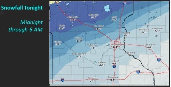
Here’s a look at potential snow amounts overnight through 6 a.m. Monday:

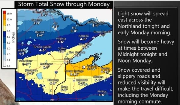
Adding the snow amounts after 6 a.m. brings storm totals to this:

Twin Cities metro area storm totals by noon on Monday could range from around 2 inches in the far south metro to around 5 inches in the far north metro, including Anoka county.
Here’s a look at the higher storm totals expected to the north and northeast:

Parts of west-central Minnesota could also see some 6+ inch snow totals:

Advisories and warnings
Winter weather advisories for snow, slippery roads and reduced visibilities start at 9 p.m. Sunday from west-central Minnesota to east-central Minnesota and up to Brainerd and Duluth. Those advisories end at noon on Monday.

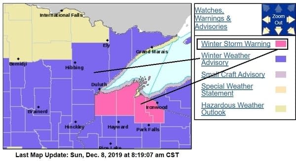
Winter weather advisories start at midnight Sunday night and run to noon Monday in Lake and Cook counties of northeastern Minnesota plus Anoka county of the north metro. Winter weather advisories go from midnight Sunday night to 6 p.m. Monday in parts of northwestern and west-central Wisconsin. Douglas, Bayfield and Ashland counties of northwestern Wisconsin are in a winter storm warning midnight Sunday night to 6 p.m. Monday:

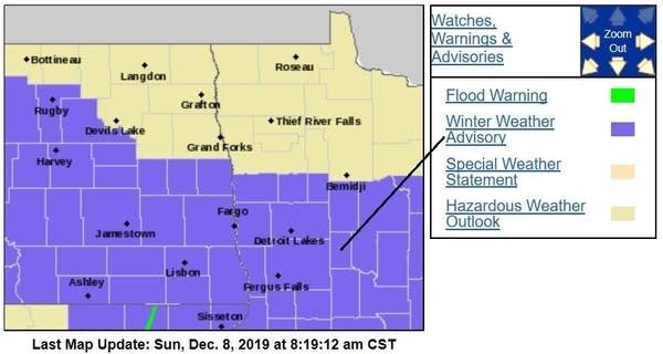
West-central Minnesota and parts of northwestern Minnesota have winter weather advisories Sunday evening into Monday morning:

Winter weather advisories begin Sunday afternoon in sections of North Dakota.
You can check for forecast updates and updated advisories and warnings from the Duluth, Twin Cities and Grand Forks offices of the NWS.
Arctic chill moves in after the snow
Our second weather headline is the blast of arctic air that spreads across Minnesota and Wisconsin after the snow.
Sunday highs have already occurred in most areas, with nearly steady or slowly falling temperatures Sunday afternoon.
Monday highs are chilly:

It’ll also be windy on Monday.
Tuesday highs are in the single digits below zero across much of northern Minnesota and slightly above zero in the south:

Our coldest morning will be on Wednesday, with teens below zero in many locations:

Some spots in central and northern Minnesota will probably dip into the 20s below zero early Wednesday.
Twin Cities metro area highs are projected to reach about 4 above zero on Wednesday, followed by lower 20s Thursday and around 30 on Friday. That’ll be a welcome temperature rebound late in the week!
Programming note
You can hear my live weather updates on Minnesota Public Radio at 7:35 a.m., 9:35 a.m. and 4:35 p.m. each Saturday and Sunday.