Plowable snow and -15 degrees next week?
Forecast models zeroing in in Arctic outbreak next week

Get ready Minnesota.
Next week looks like the coldest week so far in this (meteorological) winter season. The combination of Monday snow followed by a run of subzero temperatures will make for a significant winter weather challenge next week.
First, we enjoy a fairly mild weekend. It should be a good weekend for those who want to get out and enjoy our ample early December snow cover.

Here’s my latest thinking on how the forecast models are handling events next week.
Create a More Connected Minnesota
MPR News is your trusted resource for the news you need. With your support, MPR News brings accessible, courageous journalism and authentic conversation to everyone - free of paywalls and barriers. Your gift makes a difference.
Monday snow
All indications still point to accumulating snow Monday across much of Minnesota.
It’s still too early to be precise storm track and accumulations, but it looks like travel and rush hours will be significantly impacted Monday. The Canadian model is typical of solutions that bring snow to Minnesota Monday.

Right now most models favor the heaviest snow near the Twin Cities surrounding the midday hours. But models are often too fast with systems a few days out. So stay tuned on timing.
Arctic outbreak
The season’s coldest air mass so far blows in behind Monday’s clipper. The upper air trajectory next week blows straight from the Arctic Circle into Minnesota.

The range of forecast solutions favors Arctic air from Tuesday until at least Friday. We could string together 3-4 subzero mornings next week. And early indications are temperatures may struggle to reach the zero mark Tuesday and Wednesday afternoons.
It appears the coldest core of next week’s Arctic air mass will pass over Minnesota Wednesday morning. The European model is in the middle range between the GFS and Canadian models fro minimum temperatures Wednesday morning. The Euro cranks out a brisk minus 17 for the Twin Cities and minus 22 for St. Cloud Wednesday morning.
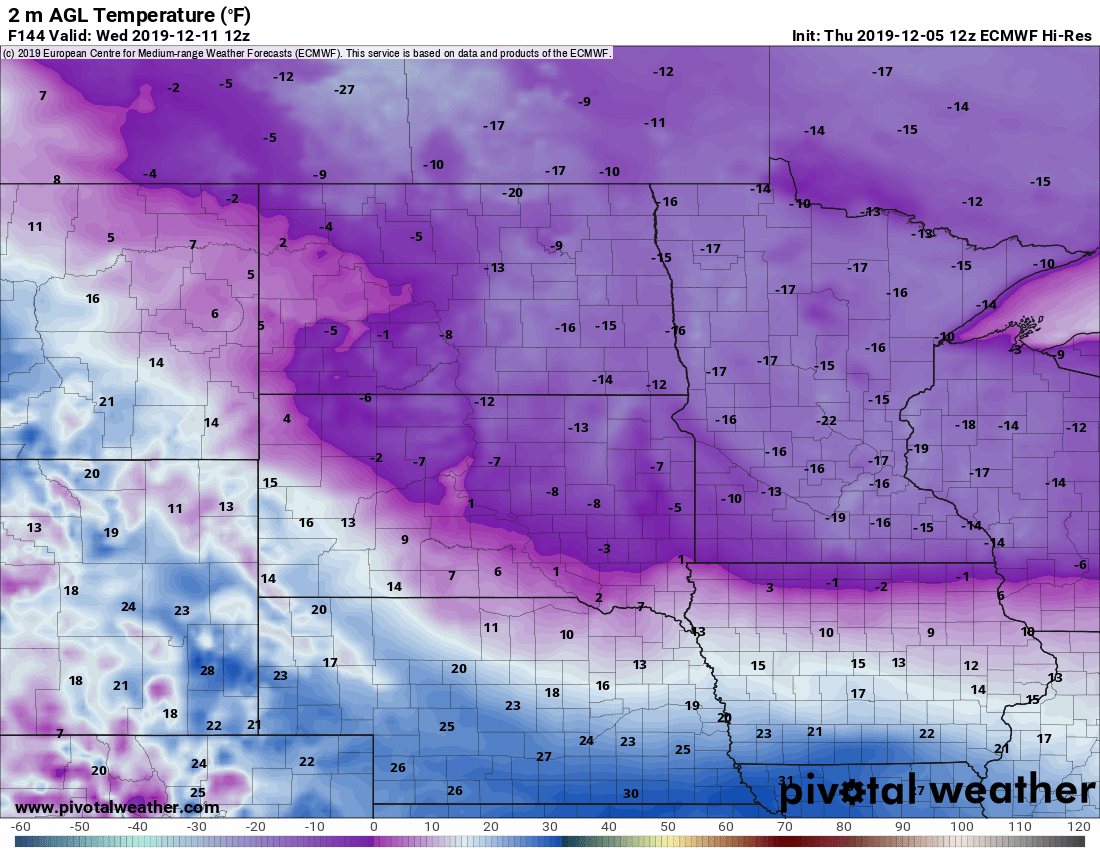
At this point, a range of temperatures between 10 and 20 below zero looks likely for most of Minnesota next Wednesday morning.
Enjoy our relatively mild weekend, and stay warm next week Minnesota.