Snowstorm update for North Dakota and northern Minn.; windy with some flakes in the metro
Milder temps return next week
A snowstorm has kept highways closed across much of eastern North Dakota. At 8 a.m. Saturday, the North Dakota Department of Transportation indicated these road conditions:

Road closures included I-94 from Fargo to Bismarck. I-29 from Fargo to the Canadian border was reopened by mid-morning, with a cautionary note from the North Dakota Department of Transportation:
I-29 OPEN
NDDOT & NDHP have OPENED I-29 from Fargo to the Canadian border. Motorists should be aware that hazardous driving conditions exist and No Travel is Advised in the area. Because of heavy rains this fall there is extra concern for motorists due to water filled ditches along I-29 and other roadways in central and eastern North Dakota.
This message is a timely reminder:
Periods of snow will linger over eastern North Dakota plus much of Minnesota and western Wisconsin today, then become more intermittent Saturday night. Southern Minnesota, the Twin Cities metro area and west-central Wisconsin will see off and on snow showers this Saturday and Saturday evening, possibly mixed with rain showers at times Saturday afternoon. A few light sprinkles or flurries are possible on Sunday.
Create a More Connected Minnesota
MPR News is your trusted resource for the news you need. With your support, MPR News brings accessible, courageous journalism and authentic conversation to everyone - free of paywalls and barriers. Your gift makes a difference.
The National Oceanic and Atmospheric Administration's North American Mesoscale forecast model shows the potential precipitation pattern from Saturday through Sunday:

Warnings and advisories
Blizzard warnings continue until 1 p.m. this Saturday for much of eastern North Dakota, but they have been dropped near the Red River Valley:

Updates on warnings and advisories can be found on the National Weather Service Grand Forks, N.D., site. A winter weather advisory continues until 1 p.m. in Douglas, Stevens and Pope counties of west-central Minnesota due to snow and blowing snow, and until 7 p.m. in Traverse and Big Stone counties.
Portions of northeastern Minnesota are in a winter weather advisory until 4 p.m. this Saturday, due to snow and slippery roads:

Saturday snow totals could reach 3 inches to 6 inches in the higher elevations near the North Shore of Lake Superior:

Updates on the northeastern Minnesota snow and advisories can be found here.
Updated weather information can be heard on the MPR network, and you’ll also see updated weather info on the MPR News live weather blog.
Temperature trends
Saturday highs will be in the 30s across most of Minnesota and western Wisconsin., but a few spots in the Twin Cities metro area and southeastern Minnesota could touch 40.
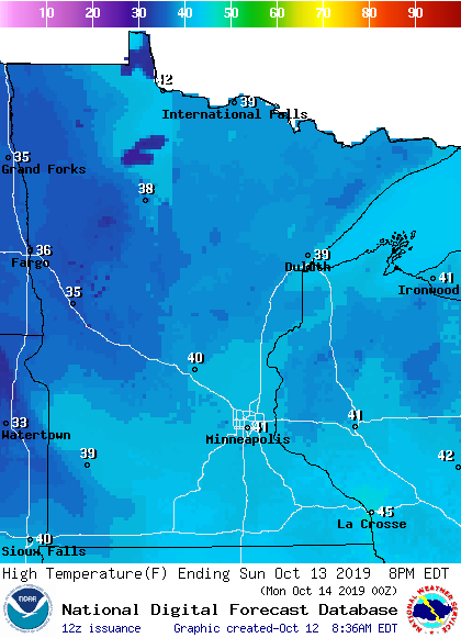
Highs Sunday will be mainly in the 30s in northern and central Minnesota with some lower 40s elsewhere, including the Twin Cities:
It has to get warmer, right? Twin Cities metro area highs are projected to reach the mid to upper 40s Monday through Wednesday, then upper 50s Thursday and around 60 on Friday.
Fall color update
If you still plan on doing some leaf-peeping, here’s the latest fall color report from the Minnesota Department of Natural Resources:

Keep in mind that the fall color report includes all deciduous trees, not just maples. A Wisconsin fall color report is also available.
Programming note
You can hear my live weather updates on Minnesota Public Radio at 7:49 a.m. Thursdays and Fridays and at 7:35 a.m., 9:35 a.m. and 4:35 p.m. each Saturday and Sunday.