Tracking the Thaw: Models hint at even warmer air next 1-2 weeks

Thaw Thursday
Thursday may be the day many Minnesotans have been waiting for for months.
The first in a series of warm fronts gushes into Minnesota Thursday. The early morning southerly breeze brings a chill at first, but by late afternoon the streets are full of brand new emerging melt ponds from the Land of 10,000 roadside glaciers.
New icicles form as your roof starts to shed a winter's worth of snow. You may suddenly realize there's pavement under that driveway you haven't seen since early December.
Create a More Connected Minnesota
MPR News is your trusted resource for the news you need. With your support, MPR News brings accessible, courageous journalism and authentic conversation to everyone - free of paywalls and barriers. Your gift makes a difference.
Weather Tip: Fill your car's windshield washer tank with blue juice ASAP. You'll be glad you did.
24 degrees - High at MSP Airport Wednesday (warmest day in 2 weeks)
19" snow depth at MSP Airport
[image]
Tracking the thaw
Thursday's warmth is just the first wave. It will feel noticeably milder Thursday afternoon and into Friday, before a temperature speed bump (aka, cold front) slides in Saturday.
Here's a closer look at the first wave of milder air pushing into the Twin Cities metro area Thursday.

Second warm wave Sunday
The second wave of milder air gushes in Sunday and Monday, This one will do an even better job of melting snow, and making you feel like winter may finally be on the wane.
Again, the European Centre for Medium-Range Weather Forecasts model is the most aggressive with the warm up.

As the jet stream lifts slightly north Minnesota remains in the path of a push and pull series of alternating warm and cool fronts. Translation? It warms up with each passing warm front, then cools in between as the next cool front glances by. But no full on arctic surges appear on the horizon.

By Monday, 40 looks like a good bet from the metro south, with 30s all the way north to Canada. Temperatures in the 50s and even 60s should wipe out all remaining snow cover to the southwest of Minnesota.

That opens the door for even milder future warm fronts from the south and west in the coming weeks. It's part of the process that triggers spring in the Upper Midwest.
Longer range: upper 40s and rain?
The models are remarkably consistent with the evolving jet stream patterns. As the jet lifts gradually north into Canada, each successive warm air push gets a little milder.
The latest 16-day Global Forecast System model hints at a sustained period of high temperatures in the mid- to upper 40s, and even a few nights with lows above freezing in the metro after St. Patty's Day.
It's still far enough away to be (very) skeptical, but the GFS is also winding up a potentially warmer spring storm that could bring rain -- followed by some wet March snow to Minnesota.
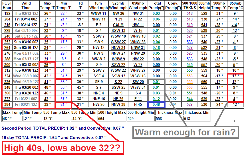
If we get that kind of sustained warmth followed by a warm spring rain, our snow cover situation could look very different in about two weeks.
Stay tuned!